Email your answers, homework and course questions to: sharon.lord@croftonacademy.org.uk

Saturday 31 January 2009

General Information: Exam Paper Structure

June Exam Paper Structure (Foundation and Higher Tier)

This question paper has three sections; you must answer three questions, one from each section:

Section A: candidates answer either Question 1 (Rivers) or Question 2 (Coasts)
Section B: candidates answer either Question 3 (Tectonic) or Question 4 (Climatic)
Section C: candidates answer either Question 5 (Development) or Question 6 (Development)

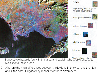
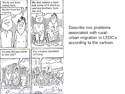
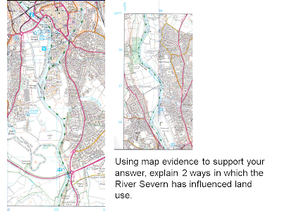
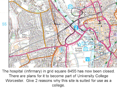
There is a separate Resource Booklet that will contain Ordnance survey maps, diagrams and cartoons.

The Exam Paper covers three themes. The themes and key investigation questions are listed below. During the GCSE Geography course you have been answering the key investigation questions.

Theme 2:
Rivers:
• How do systems ideas help us to understand physical processes that operate in a river basin?

• How does river flooding illustrate the interaction between natural processes and human activity?

• What processes and factors are responsible for distinctive landforms within a river basin?

Coasts:
• What processes and factors are responsible for distinctive coastal landforms?

• Why is the management of coastlines important?

Theme 3:
Natural Hazards:
• What is the global distribution of different types of natural hazard?

• What natural processes cause different types of natural hazards?

• How do natural hazards affect people and places in parts of the world with different levels of development?

• How can human activities affect the impact of natural hazards?

• How can people and places be protected from the impact of natural hazards?


Theme 4:
Economic Development:
• What is meant by "development"?

• How and why are there variations between the employment structures of different countries?

• What determines the location of different economic activities?

• How do multinational companies affect development?

• How can economic activity affect the physical environment at a variety of scales including global

Thursday 29 January 2009

General Information: Command Words

Command Words

When completing your GCSE Geography exam you must read the question carefully and answer it in the right way to make sure that you get as many marks as possible. Always use geographical terms in your answers e.g. compass directions, use the scale of the map, give grid references.


Here are some of the command words that you may be given:

Annotate - add notes or labels to a map or diagram to explain what it shows.

Compare - look for ways in which features or places are similar or different. e.g. a city in an LEDC compared to a MEDC

Complete - add to a map or graph to finish it off.

Contrast - look for the differences between features or places. Often the question will ask you to compare and contrast.

Define - explain what something means e.g. freeze-thaw.

Describe - give details about what a map or diagram shows.

Discuss - usually wants a long answer, describing and giving reasons for or explaining arguments for and against.

Draw - a sketch map or diagram with labels to explain something.

Explain or account for - give reasons for the location or appearance of something.

Factors - reasons for the location of something such as a factory.

Give your ( or somebody else’s) views - say what you or a particular group think about something , for example should limestone quarries be allowed in the Peak District.

Identify - name, locate, recognise or select a particular feature or features, usually from a map, photo or diagram.

Mark - put onto a map or diagram.

Name, state, list - give accurate details or features.

Study - look carefully at a map, photo, table, diagram etc. and say what it shows.


With reference to /refer to examples you have studied - give specific details about your case studies.

With the help of/using the information provided - make sure you include examples from the information, including grid references if it is a map.

Wednesday 28 January 2009

General Information: Picture and Map Questions

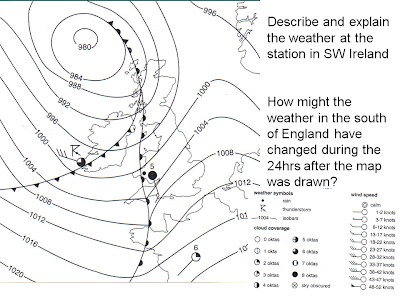
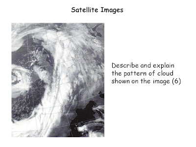
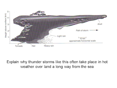
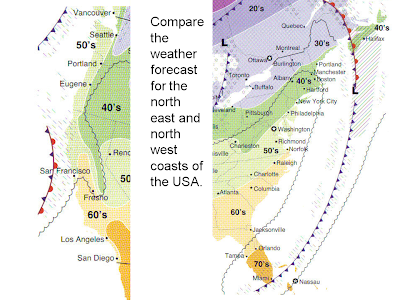
Look at how images, pictures and maps are used in the final exam


Tuesday 20 January 2009

Theme 1: Rivers - General Revision

Rivers

Water (Hydrological) Cycle
The continuous cycle of water between the sea, land and atmosphere.
There are five main processes in the hydrological cycle, these are:
1. Condensation
Water vapour changes back into water (cloud formation)
2. Evaporation
The transfer of water from the sea and the land to the air as water vapour
3. Precipitation
Any form of moisture falling from the atmosphere e.g. sleet, hail, snow, rain
4. Transpiration
Transfer of water from vegetation to the air as water vapour
5. Surface run-off
Water flowing over the surface of the earth, e.g. river

In the hydrological cycle water can be stored as snow and ice, in lakes, as ground water and in oceans and seas.

Drainage Basins
A drainage basin is an area of land drained by a river and its tributaries.

Features of a drainage basin:
1. Water shed
An area of high land which forms the edge of a river basin
2. Tributary
A small river flowing into a large river
3. Confluence
The point where two rivers meet
4. The source
Where a river starts
5. Mouth
Where a river flows into (lake or sea)


Erosion
Erosion involves the wearing away of rock and soil found along the river bed and banks. Erosion also involves the breaking down of the rock particles being carried downstream by the river.

There are four main forms of river erosion:

1. Hydraulic action – the force of the river against the banks can cause air to be trapped in cracks and crevices. The pressure weakens the banks and gradually wears it away.
2. Abrasion - rocks carried along by the river wear down the river bed and banks.
3. Attrition - rocks being carried by the river smash together and break into smaller, smoother and rounder particles.
4. Solution - soluble particles are dissolved into the river.

Transport
Rivers pick up and carry material as they flow downstream. A river may transport material in four different ways:

1. Solution - minerals are dissolved in the water and carried along in solution.
2. Suspension - fine light material is carried along in the water.
3. Saltation - small pebbles and stones are bounced along the river bed.
4. Traction - large boulders and rocks are rolled along the river bed.

Deposition
When a river loses energy, it will drop or deposit some of the material it is carrying.

Deposition may take place when a river enters an area of shallow water or when the volume of water decreases - for example, after a flood or during times of drought.
Deposition is common towards the end of a river's journey, at the mouth.

Theme 1: Rivers - York Floods/River Ouse

Case Study 2: York Floods
When:
Most winters, August 2007, January 5th 1982

Location:
York lies on the River Ouse at a confluence with the River Foss. The Ouse catchment is bordered by high land including the North York Moors, Yorkshire Dales and Pennines.


Why:
1. Flat land
2. Heavy rainfall on the Pennines
3. Urbanisation and building on the flood plain
4. Development of sewers, drains and gutters to increase run-off back to rivers more quickly
5. Summer thunderstorms
6. Stripping peat from the Pennines
7. Rapid snowmelt
8. High tides at Hull
9. Good drainage from fields
10. Lots of tributaries

Effects:
1. Farming
Livestock affected, crops ruined, farms cut-off, farmers out of business
2. Housing
Damage to property, people forced to move out/upstairs, cut-off, needing food rations, main services cut off
3. Business
Jobs, businesses closed
4. Transport
Roads closed, infrastructure damaged, train routes affected


Effects August 2007:
Over 12cm rain fell in 8 days
Hard to get insurance
Businesses closed and lost trade
2 River Foss flood pumps failed
The A59 was partially blocked by a landslide
Water table high through winter
Saturated soil
More than 350 houses flooded
Flood defences built to withstand river level rise of 5.43m
80% of roads into city closed including A1
1600 bridges checked for damage
Crops destroyed
Number of tourists dropped
5000 sand bags used
3000 put on evacuation alert
River Ouse reached 5.38m above normal level.
Many buildings had to be gutted
Trains cancelled

Prevention:
1. Land use zoning e.g. St George's Field carpark / York racecourse
2. Flood walls
3. Carparks incorporated into the design of flats (bottom level left to flood)
4. Soft technology responses
5. Sand bags
6. Pumping water back into the river
7. Foss flood barrier
8. Ings (low-lying land allowed to flood until the river level dropped)
9. Embankents
10. Flood gates
Predictions:
1. Rain gauge
2. Satellite Information

Theme 1: Rivers - Boscastle Floods/River Valency

Case Study 1:

Flooding, Boscastle, North Cornwall 16 August 2004

Location:
Boscastle is the only natural harbour for 20 miles along the North Cornwall Coast. For a hundred years the village was a thriving port, but the coming of the railways, whilst ending the isolation of North Cornwall, soon saw its decline as a trading port. Since then however, Boscastle has developed as a tourist destination with thousands of people visiting the village every Summer.
Boscastle village, clings to the side of the Valency valley. The High Streethave many properties with traditional stone and slate porches, and large slate flagstones leading up the garden path. Amongst the tourist attractions are Craft shops, a Witches Museum, a disused watermill, even a bakers and fruit shop. Old inns such as the Cobweb, and the Napoleon.

Effects:
Cars were swept out to sea, bridges were washed away and people clung to rooftops and trees for safety as torrential rain hit the area.
Emergency workers mounted a huge operation to rescue residents and holidaymakers along a 32-km (20-mile) stretch of the north Cornwall coast around Boscastle.

Eyewitness Account:
"Within an hour of arriving there as a tourist, I watched 80 cars being picked up like dinky toys and doing their convoluted dance out to sea. Within three hours half a bridge was washed away, many buildings were destroyed, people's houses and possessions floated away, roads were lifted up and crashed down onto cars like the jaws of a monster masticating its prey."

Seven helicopters from the Coastguard, the Royal Navy and the Royal Air Force hovered overhead, winching people trapped by the churning brown waters to safety.
As the tide and the flood waters receded on Tuesday morning, police divers searched the harbour as a police "body recovery" team stood by.
Cars, boulders and uprooted trees were strewn through the streets. Some shops had been torn in half by the floodwaters, which struck at 1445 GMT.
At the flood's peak some roads were submerged under 2.75 metres (9 feet) of water, and rescuers described the village as "devastated".
Damage to property:
The Museum of Witchcraft has been severely affected by the floods.
The Museum of Witchcraft, houses the world’s largest collection of witchcraft related artefacts and regalia. The museum has been located in Boscastle for over forty years and is amongst Cornwall’s most popular museums.
Almost 50% of the artefacts in the storeroom of The Museum of Witches were lost, and due to the fact access was almost impossible for nearly three weeks the silt had time to destroy quite a lot of the pieces.
Cause:
The flash flood at Boscastle was caused by a collision of winds. The day had been very warm, drawing in sea breezes along the coast.
When they joined forces with a wet southerly air flow they shot upwards with a dangerous mix of warm, moist, highly unstable air. Nearby Bodmin Moor thrust up the air mass even higher.
A line of thunderclouds rocketed over 10km high, their tops streaming into anvil shapes as high-level winds swept air away from the storm, helping suck more air from below. The thunderclouds grew so tall that they created intense downpours leading to more than 5 inches of rain falling around Boscastle in just a few hours, and possibly more over higher ground.
With the ground already saturated from recent rains, the storm waters were funnelled down steep river valleys and burst

Huge funnels:
Whilst torrential rain is key to the onset of flash flooding, the drainage and topography of the surrounding area determines the scale and impact of the event. When there is torrential rain that cannot be soaked up or drained away, this leads to ‘run-off’ – water running over the soil rather than sinking into it.
This run-off can cause localised but severe flooding. In places such as Boscastle, steep-sided valleys can act as huge funnels for this water, channelling it very quickly down to the sea, and sometimes with devastating results for local communities.

Effect on tourism:
About 90% of Boscastle’s economy is dependent on tourism. After the flood, more than 20 accommodation providers were forced to shup, many of them individually owned bed and breakfasts. As about two thirds of the business is done during the six week school holiday, the effects were even more devastating with half the three weeks remaining.


The Response:

Monday 19 January 2009

Theme 1: Coasts - Coastal Management (Holderness)

Theme 1: Coasts - General Revision Notes

Waves:

The size of a wave depends on its fetch. The fetch is the distance a wave travels. The greater the fetch, the larger the wave. Wind also has a significant effect on the size of waves. The stronger the wind the larger the wave.

As a wave approaches a beach it slows. This is the result of friction between the water and the beach. This causes a wave to break.

There are two main types of wave. These are constructive and destructive waves. :

Constructive waves build beaches. Each wave is low. As the wave breaks it carries material up the beach in its swash. The beach material will then be deposited as the backwash soaks into the sand or slowly drains away. These waves are most common in summer.

Destructive waves destroy beaches. The waves are usually very high and very frequent. The back wash has less time to soak into the sand. As waves continue to hit the beach there is more running water to transport the material out to sea. these waves are most common in winter.

Coastal Processes:
There are three main processes at work in the sea. These are erosion, transportation and deposition.

Erosion:
Erosion is destructive waves wearing away the coast.
There are four main processes which cause coastal erosion. These are corrasion/abrasion, hydraulic action, attrition and corrosion/solution.

Corrasion/abrasion is when waves pick up beach material (e.g. pebbles) and hurl them at the base of a cliff.

When waves hit the base of a cliff air is compressed into cracks. When the wave retreats the air rushes out of the gap. Often this causes cliff material to break away. This process is known as hydraulic action.

Attrition is when waves cause rocks and pebbles to bump into each other and break up.

Corrosion/solution is when certain types of cliff erode as a result of weak acids in the sea.

Transportation:
Transportation is the movement of material in the sea and along the coast by waves. The movement of material along the coast is called longshore drift.

Longshore Drift:
Longshore drift happens when waves moves towards the coast at an angle. The swash (waves moving up the beach) carries material up and along the beach. The backwash carries material back down the beach at right angles. This is the result of gravity. This process slowly moves material along the beach.
Longshore drift provides a link between erosion and deposition. Material in one place is eroded, transported then deposited elsewhere.

Transportation:
Although longshore drift is the main process of transportation the material moves in four different ways. These are:

Traction - large material is rolled along the sea floor.

Saltation - beach material is bounced along the sea floor.

Suspension - beach material is suspended and carried by the waves. .

Solution - material is disolved and carried by the water.


Deposition:
Deposition is when eroded material is dropped by constructive waves. It happens because wave have less energy. Deposition creates a range of landforms.

Bays and headlands:
Headlands form along coastlines in which bands of soft and hard rock outcrop at right angles to the coastline. Due to the different nature of the rock erosion occurs at different rates. Less resistant rock (e.g. boulder clay) erodes more rapidly than less resistant rock (e.g. chalk).

Erosion of a headland:
A headland is an area of hard rock which sticks out into the sea. Headlands form in areas of alternating hard and soft rock. Where the soft rock erodes bays are formed either side of the headland. As the headland becomes more exposed to the wind and waves the rate of its erosion increases. When headlands erode they create distinct features such as caves, arches, stacks and stumps.

The formation of a stack:
Stage 1
Waves attack a weakness in the headland.

Stage 2
A cave is formed.

Stage 3
Eventually the cave erodes through the headland to form an arch.

Stage 4
The roof of the arch collapses leaving a column of rock called a stack.

Stage 5
The stack collapses leaving a stump.


Coastal Deposition is when the sea drops or deposits material. This can include sand, sediment and shingle.

Beaches:
The beach is the area between the lowest spring tide level and the point reached by the storm waves in the highest tides. Every beach is different but they are usually made up of material deposited on a wave-cut platform.


Spit:
Longshore drift moves material along a coastline. Where there is an obstruction or the power of the waves is reduced the material is deposited. Where rivers or estuaries meet the sea deposition often occurs. The sediment which is deposited usually builds up over the years to form a long ridge of material (usually sand or shingle). Such a ridge is called a spit. Spurn Head on the Holderness Coast is an example of this feature.

Why defend the coast?
There are a number of reasons for protecting the coast. Coastlines tend to be very heavily populated. They are areas of high economic value due to tourism. Coastlines are particularly prone to flooding. Finally, they are fragile ecosystems which take a long time to recover if they are destroyed.

Hard Engineering:
Hard engineering approaches tend to be expensive, last only a short amount of time, are visually unattractive and unsustainable. They often increase erosion in other places further down the coast.

Hard Engineering Techniques:

Groynes
Groynes are wooden barriers constructed at right angles to
the beach to retain material. Material is trapped between these groynes and cannot be transported away by longshore drift. Groynes encourage a wide beach which helps absorb energy from waves, reducing the rate of cliff erosion. Cheap, retain wide sandy beaches and do not affect access to the beach. Beaches to the south of the defences are starved of beach material due to their affect on long shore drift. £7000 each

Sea Walls
Sea walls are usually built along the front of cliffs, often to protect settlements. They are often recurved which means waves are reflected back on themselves. This can cause the erosion of material at the base of the sea wall. Provide excellent defence where wave energy is high, reassures the public and long life span. Expensive, can affect beach access, recurved sea walls can increase the erosion of beach material. £3000-4000/m

Reventments
Traditionally these have been wooden slatted barriers constructed towards the rear of beaches to protect the base of cliffs. Energy from waves is dissipated by them breaking against the reventments. In recent times concrete reventments such as accropodes have been used in places such as Scarborough. Less beach material is eroded compared to a sea wall. Cheaper and less intrusive than a sea wall. Short life span and unsuitable where wave energy is high. £2000/m

Rock armour / boulder barriers
These are often large boulders placed along the base of a cliff to absorb energy from waves. Cheap and efficient. Unattractive, dangerous access to beach, costs increase when rock is imported. £3000/m

Gabions
This is where rocks and boulders are encased in wired mesh. They absorb the energy from waves. Cheap and efficient. Shorter life span than a sea wall. Visually unattractive. £100/m

Off-shore breakwater
These are large concrete blocks and boulders located off shore to change the direction of waves and reduce longshore drift. They also help absorb wave energy. Beaches retain natural appearance. Difficult to maintain, unattractive, does not protect the cliffs directly and does not stop beach material from being eroded.


Soft Engineering:
Soft engineering approaches are less expensive, are more long term, attractive and sustainable as they work with natural processes.

Soft Engineering Techniques:

Beach nourishment
Beaches are made higher and wider by importing sand and shingle to an area affected by longshore drift. Cheap, retains the natural appearance of the beach and preserves the natural appearance of the beach. Off shore dredging of sand and shingle increases erosion in other areas and affects the ecosystem. Large storms will require beach replenishment, increasing costs. £20 /cu.m

Managed retreat:
This is when areas of coast are allowed to erode. This is usually in areas where the land is of low value. Managed retreat retains the natural balance of the coastal system. Eroded material encourages the development of beaches and salt marshes. People lose their livelihood e.g. farmers. These people will need to be compensated.

Theme 1: Rivers Quick Questions

Quick Questions: Rivers

1. What does the hydrological cycle show?

2. Describe three flows in the hydrological cycle.

3. Describe three stores in the hydrological cycle.

4. What is a drainage basin?

5. Name two outputs from a drainage basin system.

6. What happens at a confluence?

7. Describe freeze-thaw weathering.

8. What is biological weathering?

9. What does a river’s long profile show?

10. Describe the cross profile of a river’s lower course.

11. What is corrosion?

12. Name two processes of transportation.

13. When does deposition occur?

14. Where do waterfalls form? Name an example.

15. How is a gorge formed?

16. Why do rivers have to wind around interlocking spurs.

17. What is a flood plain?

18. Describe how levees are formed.
19. Name one type of delta and describe what it looks like.

20. Where is the current fastest on a meander.

21. Name the landform created when a meander is cut off by deposition.

22. What do the contour lines on a map show?

23. Give two pieces of map evidence for a waterfall.

24. Give two pieces of map evidence for a river’s lower course.

25. Describe three landforms in the valley of a river you have studied.

26. What is river discharge?

27. How does impermeable rock affect river discharge?

28. Describe one physical cause of flooding.

29. Describe one human cause of flooding.

30. Name a hard engineering strategy and describe its benefits.

31. Name a soft engineering strategy and describe its disadvantages.

32. Why are hard engineering strategies usually less sustainable than soft engineering strategies?

33. a) Name a river in an MEDC or an LEDC which has been affected by flooding.

b) Describe the primary effects of a flood on that river.

c) Describe two flood protection measures that are used for that river.

Friday 16 January 2009

Theme 3: Nat Haz (Climatic) - General Revision

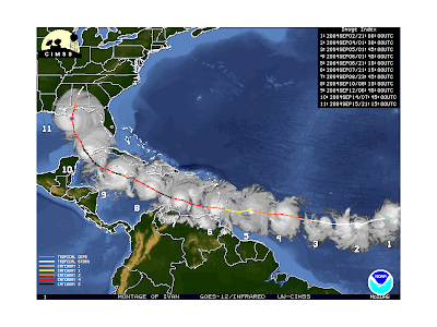
Tropical Storms

Names
Tropical storms are also known as:


Hurricanes = North Atlantic
Typhoons = Pacific
Tropical Cyclones = South East Asia
Willy-Willies = Australia

Conditions required for formation:

· Over Oceans
· Ocean temperature over 27°c
· Water heated to a depth of several metres
· Close to the East Coast of continents
· Late summer or early Autumn, when sea temperatures are at their highest (notice how hurricanes always hit America around September/October!)

Causes of tropical storms
· Air on surface of ocean is heated (it also contains lots of moisture)
· Hot, humid air rises, cools and condenses. Clouds form.
· Rising air creates low pressure. Air rushes in to fill gap left by rising air.
· Rotation of the earth means winds do not blow straight. Winds circle towards the centre.
· The storm continues to feed itself.
· Whole system moves westwards towards land.
· When the system crosses the land it losses its source of heat and moisture. The tropical storm losses its energy and dies out.

Managing the effects of tropical storms
Reducing the effects of tropical storms includes:
· Studying tropical storms once they form
· Providing an early warning system
· Long-term planning in areas prone to tropical storms

Theme 3: Nat Haz - Tropical Storms