 Case Study 2: York Floods
When:
Most winters, August 2007, January 5th 1982
Location:
York lies on the River Ouse at a confluence with the River Foss. The Ouse catchment is bordered by high land including the North York Moors, Yorkshire Dales and Pennines.
Why:
1. Flat land
2. Heavy rainfall on the Pennines
3. Urbanisation and building on the flood plain
4. Development of sewers, drains and gutters to increase run-off back to rivers more quickly
5. Summer thunderstorms
6. Stripping peat from the Pennines
7. Rapid snowmelt
8. High tides at Hull
9. Good drainage from fields
10. Lots of tributaries
Effects:
1. Farming
Livestock affected, crops ruined, farms cut-off, farmers out of business
2. Housing
Damage to property, people forced to move out/upstairs, cut-off, needing food rations, main services cut off
3. Business
Jobs, businesses closed
4. Transport
Roads closed, infrastructure damaged, train routes affected

Effects August 2007:
Over 12cm rain fell in 8 days
Hard to get insurance
Businesses closed and lost trade
2 River Foss flood pumps failed
The A59 was partially blocked by a landslide
Water table high through winter
Saturated soil
More than 350 houses flooded
Flood defences built to withstand river level rise of 5.43m
80% of roads into city closed including A1
1600 bridges checked for damage
Crops destroyed
Number of tourists dropped
5000 sand bags used
3000 put on evacuation alert
River Ouse reached 5.38m above normal level.
Many buildings had to be gutted
Trains cancelled
 Prevention:
1. Land use zoning e.g. St George's Field carpark / York racecourse
2. Flood walls
3. Carparks incorporated into the design of flats (bottom level left to flood)
4. Soft technology responses
5. Sand bags
6. Pumping water back into the river
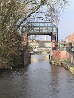
7. Foss flood barrier
8. Ings (low-lying land allowed to flood until the river level dropped)
9. Embankents
10. Flood gates
 Predictions:
1. Rain gauge
2. Satellite Information
No comments:
Post a Comment